

(Click on photo to enlarge)
Russia and China Fail to Act While Residents Suffer Death, Destruction
Human Rights Watch
March 2, 2012
"(New York) – New satellite imagery and eyewitness accounts reveal that the bombardment of the Baba Amr neighborhood in Homs has inflicted widespread destruction and a large number of deaths and severe injuries of civilians, Human Rights Watch said today. The bombardment has severely restricted movement and relief efforts and deprived thousands of civilians of the ability to access the most basic commodities, Human Rights Watch said.
Local sources have reported that approximately 700 civilians have been killed and thousands wounded in Homs since the Syrian military began its current assault on the city on February 3, 2012. Indiscriminate shelling and sniper fire has caused most of the casualties in Baba Amr, which is a residential area where elements of the armed opposition have sought refuge. Human Rights Watch interviewed 15 Homs residents who escaped the city in the last two weeks, as well as two foreign correspondents who spent time in Baba Amr during the military assault.
“These new satellite photos and witness accounts show the extent of the brutality unleashed on Baba Amr," said Sarah Leah Whitson, Middle East director at Human Rights Watch. “Despite the killing, Russia and China continue to block any international action.”
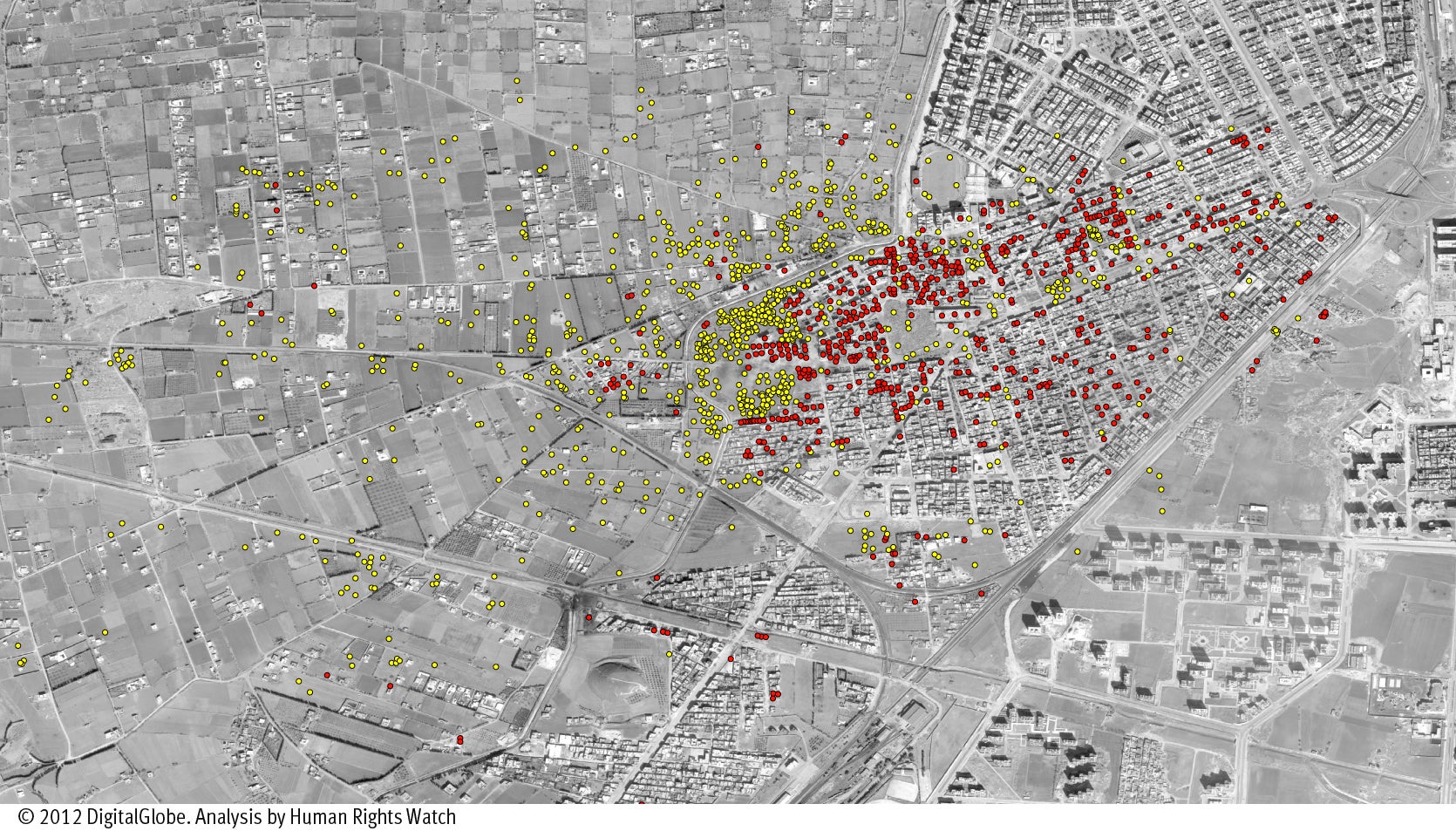
Human Rights Watch acquired and analyzed this commercial satellite image of the Baba Amr neighborhood of Homs on February 25. A wide view of the image clearly shows the extensive damage caused by the use of surface-delivered explosive weapons in a populated area. The image reflects the damage that has occurred since previous images were taken between four and six weeks ago.
Analysts have overlaid the large-scale image of Baba Amr with symbols to highlight certain features:
- Red circles represent destroyed or damaged buildings
- Yellow circles are impact craters in open areas like fields, or roads.
At least 950 craters are visible on open lands, such as roads and farmland, from the impact of indirect fire weapons. The number of craters indicates the frequency of the attacks and how many artillery and mortar shells have fallen. There are 640 buildings in the neighborhood with visible damage. However, the damage to buildings is likely to be significantly underestimated from viewing the satellite image because views from satellite images do not show hits to the sides of buildings made by explosive weapons......"
Human Rights Watch
March 2, 2012
"(New York) – New satellite imagery and eyewitness accounts reveal that the bombardment of the Baba Amr neighborhood in Homs has inflicted widespread destruction and a large number of deaths and severe injuries of civilians, Human Rights Watch said today. The bombardment has severely restricted movement and relief efforts and deprived thousands of civilians of the ability to access the most basic commodities, Human Rights Watch said.
Local sources have reported that approximately 700 civilians have been killed and thousands wounded in Homs since the Syrian military began its current assault on the city on February 3, 2012. Indiscriminate shelling and sniper fire has caused most of the casualties in Baba Amr, which is a residential area where elements of the armed opposition have sought refuge. Human Rights Watch interviewed 15 Homs residents who escaped the city in the last two weeks, as well as two foreign correspondents who spent time in Baba Amr during the military assault.
“These new satellite photos and witness accounts show the extent of the brutality unleashed on Baba Amr," said Sarah Leah Whitson, Middle East director at Human Rights Watch. “Despite the killing, Russia and China continue to block any international action.”
Human Rights Watch acquired and analyzed this commercial satellite image of the Baba Amr neighborhood of Homs on February 25. A wide view of the image clearly shows the extensive damage caused by the use of surface-delivered explosive weapons in a populated area. The image reflects the damage that has occurred since previous images were taken between four and six weeks ago.
Analysts have overlaid the large-scale image of Baba Amr with symbols to highlight certain features:
- Red circles represent destroyed or damaged buildings
- Yellow circles are impact craters in open areas like fields, or roads.
At least 950 craters are visible on open lands, such as roads and farmland, from the impact of indirect fire weapons. The number of craters indicates the frequency of the attacks and how many artillery and mortar shells have fallen. There are 640 buildings in the neighborhood with visible damage. However, the damage to buildings is likely to be significantly underestimated from viewing the satellite image because views from satellite images do not show hits to the sides of buildings made by explosive weapons......"
No comments:
Post a Comment